Demographics of a country play a very important role in shaping its culture and history. India is no exception. India is a land of very diverse geography, terrain and weather. Its ethnic composition is a even more diverse, with hundreds of ethnically different peoples inhabiting it, speaking many languages.
The subject of my this post is also about the demographics of India, but confined only to the Muslim population and its distribution in India. This aspect of Indian demographics played the most important part in shaping the modern history of India in the twentieth century. Muslim population and its aspirations were the most important issue of the five or six decades leading to the independence. And when the independence came, it determined the borders of the modern states in the subcontinent.
I chose the data from the census of 1941, the last census before the partition. But the real problem was to make a map of India during the British Raj. India during the raj was a complicated mosaic of provinces, directly governed by the British and about 565 princely states. These were of various sizes, biggest of these was Hyderabad with an area of 213000 km.sq. But hundreds of them were so small that it was very difficult to show them even on a large size map. To make the matter worse for a cartographer, many of them were divided into several non-contiguous territories. I shall probably make no exaggeration if I say that even the viceroy would not have a map of India, clearly showing all the the political units of India.
I luckily found on internet a map published by National Geographic Society in 1946. But on this map they have been able to show less than 200 princely states. I have used the same map to make my map given below. So although this map is accurate as far as British provinces are concerned but gives just a rough idea of the princely states and their boundaries, especially the smaller ones. However, it gives a fairly accurate idea of the distribution of Muslim population in India in 1941.
The above map shows the distribution of Muslim population in India according to the census of 1941. It shows British administered provinces,with districts and the princely states. Please note that just one third of the total 565 states are shown.
(Click the map for the larger view)
The above map shows the British provinces and some of those princely states, which were ruled by Muslim rulers.
(Click the map for the larger view)
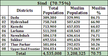
The tables given below show the population of Muslims in the provinces of British India. By that means the areas that were ruled and administered directly by the British government in Delhi.
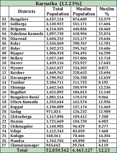
The following tables show the population of Muslim in each district of all the states, according to the census of 2001.
So finally this post is complete and ready to be published. It proved to be a hard task and took me much more time to publish it than I expected. How successful I am, you will decide. I have not analyzed the data or tried to draw any conclusion, that I would leave to readers. Your comments are most welcome.
Tariq Amir
Doha – Qatar.
December 28, 2014.


